")
")
")
Šuplja crkva, Ivoševci - Burnum
by Igor Borzić - Creation date : 03/04/2012Identity card
Ancient name(s)
Burnum
Official modern name(s)
Šuplja crkva, Ivoševci
Location
Kistanje
Commune (moderne)
Kistanje
Region (moderne)
Šibensko-kninska
Country (modern)
Croatia
Coordinate
Latitude
44.0228004
Longitude
16.0305004
Source
Google Earth
Altitude
252
Regio or provincia
Dalmatia, Illyricum
Status of the site (ancient definition)
castra / military camp , municipium
Type of the site
Habitat groupé, Site fortifié, town
Chronology
Periods
Roman empire
Late Antiquity
Early Middle Ages
Late Antiquity
Early Middle Ages
General description
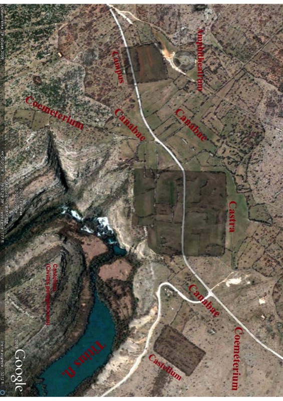
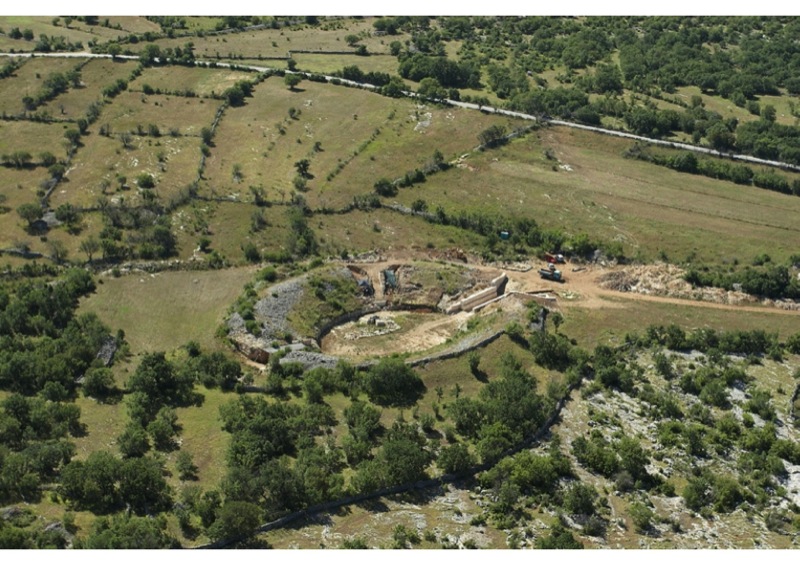
Site is located on the plateau on the right bank of Krka river in the vicinity of the river crossing Bobodol. Its name comes from Liburnian community of Burnistae, whose center was most probably located at hill-fort Gradina by Puljani on the opposite river bank. For now it is sure that Roman army encamped there some time before 6 AD and stayed there uninterruptedly until 86 AD, or maybe even later. In that time Burnum is strong and complex military base that was consisted of several registered parts: legionary camp with partly excavated principia complex (330 x 295 m; Legio XI - late Augustan-early Claudian; Legio XI Claudia Pia Fidelis - Claudian; Legio IIII Flavia Felix - Vespasian; and Legio VIII Avgvsta - Traian phase,',','); auxiliary camp (175 x 105 m; Ala I Hispanorum - late Augustan-early Claudian; Cohors II Cyrrhestarum sagittaria - Claudian; Cohors III Alpinorum and Cohors I Montanorum cR – Vespasian phase,',','); partly excavated four gated and double porched campus (160 x 160 m,',','); four gated amphitheatre (97,55 x 80 m and 44 x 37 m arena; early Claudian and Vespasian phase,',','); canabae; documented aqueductus follows terrain features (37 km long from Plavno polje to legionary camp,',','); necropolis registered along the accessing roads that comes from Scardona, Varvaria and Promona directions; prata legionis epigraphical confirmed at Uzdolje; and military bricks and tiles workshop confirmed in Smrdelje near Varvaria. Probably during the Hadrian times (118 AD at least) Burnum became a municipium Burnistarum that gathered civitas peregrinorum on Gradina by Puljani, cives Romani consistentes ad legionem at canabae and transformed legionary camp which probably became a center of civil Burnum, with basilica (18 x 71 m), cult buildings and curia on place of earlier principia. Last literary information about Burnum comes from Procopius who mentioned it as Gothic fort in Byzantine-Gothic wars, but several graves from earlymedieval period prove its existence even after these events.
Historiography
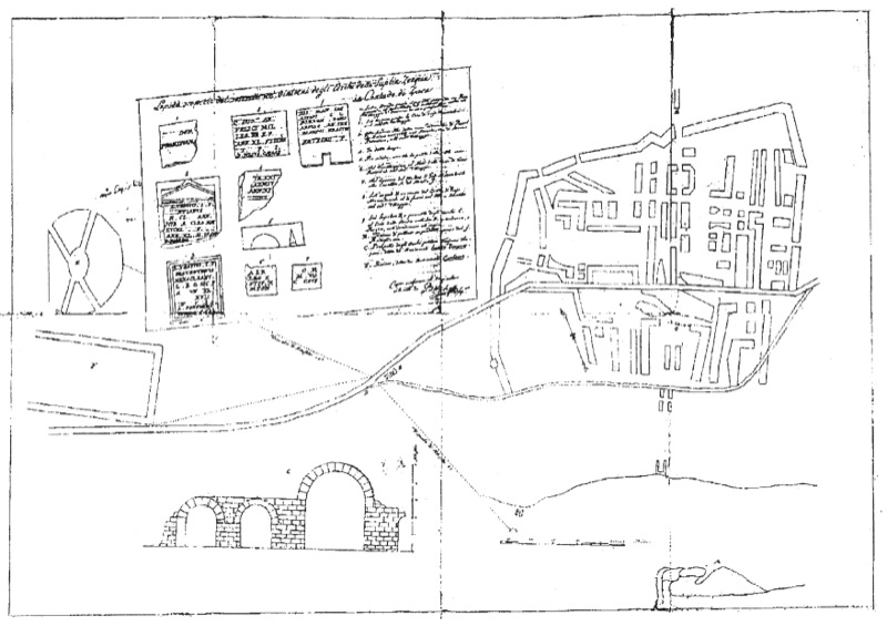
1912.-1913. – Österreichischen archäologischen Institutes in Wien excavated wide area in the centre of legionary fortress and later city of Burnum. In this occasion were undercover several phases of principia complex and a communication that goes parallel with mentioned complex and ends with Porta principalis dextra.
1973. – 1974. – Österreichischen archäologischen Institutes in Wien and Archaeoogical museum in Zadar has done revisions of forementioned excavation on small, trenchlike area. Also in this occasion aquaeduct from Plavno polje to Burnum was documented.
2003. – Municipal museum of Drniš, Department of Archaeology University of Zadar, National park of Krka and Department of Archaeology University of Bologna started big project that has several main aims: making preciselly archeo-topographical map of wider Burnum area, investigating (destructive and non-destructive), processing and presenting individual parts and opening of museum and archaeological park Burnum.
Literary sources
Βούρνον: Ptol. 2, 16, 6
Burno: Tab. Peut,
Βούρνον πολιν: Proc. 5, 16, 13-18
Burno: Tab. Peut,
Βούρνον πολιν: Proc. 5, 16, 13-18
Epigraphical sources
Burnistae: CIL III 2809 (Scardona)
M(unicipium) B(urnistarum): Suić M., VHAD 54, 1952
CIL III, 2820-2842, 6415-6420, 9890-9899, 13250 (prata legionis), 14321-14321, 14980-15015
ILjug 02 – 00830-00855
ILjug 03 – 02807-02808, 02810-02812, 02814, 02816-02820
AE 1979/00446
M(unicipium) B(urnistarum): Suić M., VHAD 54, 1952
CIL III, 2820-2842, 6415-6420, 9890-9899, 13250 (prata legionis), 14321-14321, 14980-15015
ILjug 02 – 00830-00855
ILjug 03 – 02807-02808, 02810-02812, 02814, 02816-02820
AE 1979/00446
Bibliography
Abramić 1924, p. 221-228
Glavičić & Miletić 2009, p. 75-83
Miletić 2007, p. 181-202
Miletić 2010, p. 113-142
Patsch 1897, p. 177-241
Reisch 1913, p. 113-135
Suić 1952, p. 207-217
Zaninović 1968, p. 119-129
Web site
url
apreciation
notable
Images
Legende
Burnum - Topography


Protection / Conservation
State
Propriété
public
Visible
yes
Disparu
yes
Réenterré
yes
Notes
Una parte degli vecchi scavi sono stati risepolti.
Protection
Protégé
yes
Autorité responsable
Konzervatorski ured u Šibeniku
Contacts
marko.mendusic@min-kulture.hr
J. Čulinovića 1/3, 22000 Šibenik
J. Čulinovića 1/3, 22000 Šibenik
Risk
Niveau
high
Type
fouilles clandestines
Valorisation
Excavation in progress
yes
Archaeological Park
yes
Site museum
Site museum
yes
Address
Puljani , in National park of Krka
Nearby museum
Nearby museum
yes
Address
Gradski muzej Drniš
Domovinskog rata 38
22320 Drniš
Hrvatska
Domovinskog rata 38
22320 Drniš
Hrvatska
Conservation deposit
Conservation deposit
yes
Address
Gradski muzej Drniš
Domovinskog rata 38
22320 Drniš
Hrvatska
Domovinskog rata 38
22320 Drniš
Hrvatska
Other valorisation activities
Ludi Romani, shows in amphitheatre etc.
Contacts
Gradski muzej Drniš
Domovinskog rata 38
22320 Drniš
Hrvatska
Domovinskog rata 38
22320 Drniš
Hrvatska
URI : http://adriaticummare.org/adriatlas?idSite=145
DOI : 10.21412/adriatlas_145